Поиск по библиотеке
Результаты поиска
Найдено результатов: 9.
-
 Сейсмические колебания многоэтажных зданий на основе континуальной моделиПредложена методика расчета динамических характеристик многоэтажного здания на основе континуальной пластинчатой динамической модели, разработанной в рамках теории пластин Тимошенко, описывающей сейсмические колебания зданий. Приведены формулы для определения приведенных модулей упругости, сдвига и плотности пластинчатой модели здания. Рассмотрены поперечные колебания здания при сейсмических воздействиях. Получены численные значения первых трех собственных частот и периодов собственных колебаний многоэтажного здания.
Сейсмическая безопасность зданий и сооружений -
 Ўзбекистон республикасида амалда сейсмик ҳимоя қурилмалари қўлланилган кўп қаватли бинолар ҳамда уларнинг техник ҳолатиВ данной статье были определены и сопоставлены влияние многослойных эластомерных опор на динамические характеристики опытно построенного крупнопанельного девятиэтажного здания в городе Ташкенте на основе результатов измерений в натурных условиях.
Сейсмическая безопасность зданий и сооружений -
 Assessment of seismic fault risks on spatial planning and development in aras sezs based on lulcIdentifying seismic fault zones is crucial for assessing the seismic risks and therefore affecting the land cover plan for a specific area. Urban areas built on seismically active fault zones are more susceptible to earthquakes compared to areas covered with dense forests or agricultural lands. The North- West Iran, Aras Special Development Zones (SEZs) are one of the areas with prominent land cover in near future due to its reachability to multiple countries. Analyzing the relationship between land cover types and seismic fault zones in the Aras SEZ can provide valuable insights into the susceptibility of different land cover types to seismic events. We used Land Use/Land Cover (LULC) method to assess the impact of seismic fault zones on land use in the Aras SEZs which involves evaluating the potential impact of earthquakes on different land uses and activities. This assessment can help identify areas that are most susceptible to seismic hazards and prioritize them for risk mitigation measures. In conclusion, our assessment of seismic fault risks on spatial planning and development in Aras SEZs suggests valuable insights to ensure the safety and resilience of future investments and developments.
Сейсмическая безопасность зданий и сооружений -
 В этой статье приведены общие сведения о землетрясениях, их типах, классификации. Классифицируются сейсмические условия над и под землей. Статья предназначена для требований направлений охраны труда и технической безопасности, специалистов по охране труда и технике безопасности, а также широкого круга читателей
 -
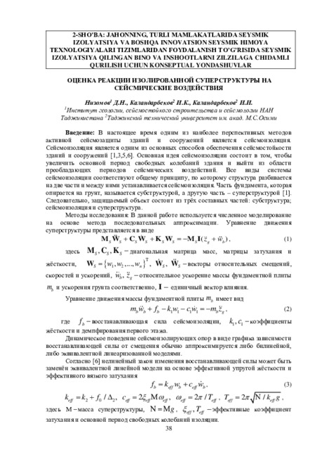 Оценка реакции изолированной суперструктуры на сейсмические воздействияВ настоящее время одним из наиболее перспективных методов активной сейсмозащиты зданий и сооружений является сейсмоизоляция. Сейсмоизоляция является одним из основных способов обеспечения сейсмостойкости зданий и сооружений [1,3,5,6]. Основная идея ссйсмоизоляции состоит в том, чтобы увеличить основной период свободных колебаний здания и выйти из области преобладающих периодов сейсмических воздействий. Все виды системы ссйсмоизоляции соответствуют общему принципу, по которому структура разбивается на две части и между ними устанавливается сейсмоизоляция. Часть фундамента, которая опирается на грунт, называется субструктурой, а другую часть - суперструктурой [1]. Следовательно, защищаемый объект состоит из трёх составных частей: субструктура; сейсмоизоляция и суперструктура.
Сейсмическая безопасность зданий и сооружений -
 В данной статье приведены общие сведения о землетрясениях, их типах, классификации. Классифицируются сейсмические условия над и под землей. Статья предназначена для требований направлений охраны труда и технической безопасности, специалистов по охране труда и технике безопасности, а также широкого круга читателей.
 -
 К вопросу управления сейсмическим действием промышленных подземных взрывов на каменном карьереМассовые промышленные подземные масштабе в народном хозяйстве, являются сейсмических волн. Иногда промышленные взрывы, используемые в широком источниками возбуждения в грунте взрывы выполняются в стесненных условиях (вблизи жилых зданий, промышленных объектов и т.д.). Сейсмические воздействия таких взрывов приобретают особо опасный характер и требует прогнозировать интенсивность сейсмического действия за ранее.
Сейсмическая безопасность зданий и сооружений -
 Биноларни лёссимон заминларда лойиҳалашда сейсмик кучлар таъсирида пайдо бўладиган деформацияларни ҳисобга олишВ данной статье приведены результаты анализов лабораторных испытаний увлажнённых лёссовых грунтов при динамических (сейсмических) нагрузках. Даны рекомендации по учёту сейсмопросадки при проектировании зданий и сооружений в сейсмоактивных районах Республики.
Сейсмическая безопасность зданий и сооружений -
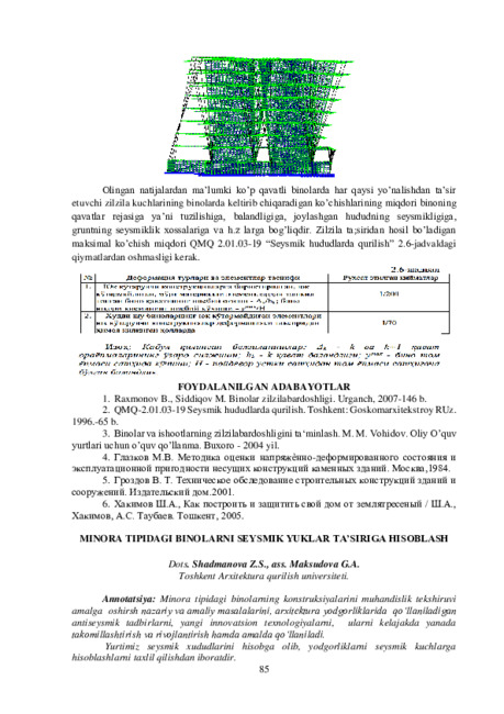 Minora tipidagi binolarni seysmik yuklar ta’siriga hisoblashMinora tipidagi binolarning konstruksiyalarini muhandislik tekshiruvi amalga oshirsh nazariy va amaliy masalalarini, arxitektura yodgorliklarida qo 'llaniladigan antiseysmik tadbirlarni, yangi innovatsion texnologiyalarni, ularni kelajakda yanada takomillashtirish va rivojlantirish hamda amalda qo ‘llaniladi. Yurtimiz seysmik xududlarini hisobga olib, yodgorliklarni seysmik kuchlarga hisoblashlarni taxli! qilishdan iboratdir.
Сейсмическая безопасность зданий и сооружений
1 - 9 из 9 результатов